In southeast Ohio, the high heat index of the last week created the possibility for severe thunderstorms. Most of the Monroe County area only witnessed darkening skies, thunder and lightning, with little to no precipitation occurring.
I was walking around outside of the office and felt a single cold drop hit my hand, within moments about 12 raindrops fell and landed on the sidewalk. I pulled out my phone to take a picture and within the 10 seconds it took me to turn on my camera, the raindrops were no where to be seen. Temperatures in the high 90s caused them to instantly disappear.
I have had many conversations lately with clients about the stresses associated with the last few months of decreased rainfall. Pastures are dry, farmers are hauling water for livestock, second cutting hay is at a 80-100% loss and everyone is being negatively affected.
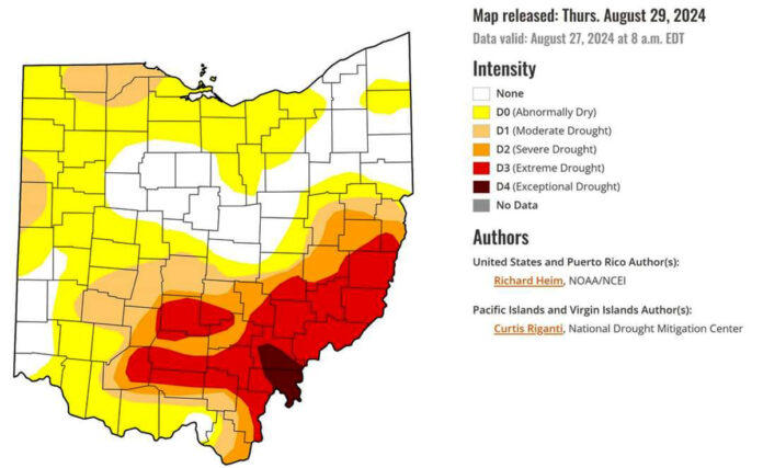
Levels of drought
Across the state we are seeing various stages of the drought: D0, abnormally dry; D1, moderate drought, D2, severe drought; D3, extreme drought; and D4, exceptional drought.
The U.S. Drought Monitor was created in 2000 as a “snapshot” of the current conditions and is updated every Thursday. The USDM identifies areas in drought and labels then by intensity, considering more than just precipitation levels. According to the USDM website, drought intensity is determined by a convergence of evidence approach, blending objective physical indicators with insight from local experts, condition observations and reports of drought impacts. This combination of the best available data, local observations and experts’ judgment makes the USDM more versatile than other drought measures. You can find more information about drought classifications at droughtmonitor.unl.edu.
Disaster Assistance through the Farm Service Agency
The Livestock Forage Disaster Program provides compensation to eligible livestock producers who have suffered grazing losses for covered livestock and who are also producers of grazed forage crop acreage of native and improved pastureland with permanent vegetative cover or acreage planted specifically for grazing.
Eligibility
According to the LFP fact sheet, an eligible livestock producer, who is a grazed forage crop producer, owns or leases grazing land or pastureland physically located in a county rated by the USDM as having a D2-D4.
Livestock that are eligible within this program include grazing animals that satisfy the majority of net energy requirement of nutrition via grazing of forage grasses or legumes and include such species as alpacas, beef cattle, buffalo/bison, beefalo, dairy cattle, deer, elk, emus, equine, goats, llamas, ostrich, reindeer or sheep.
A map of eligible counties for LFP drought can be found at fsa.usda.gov/programs-and-services/disaster-assistance-program/livestock-forage/index. For more information on the Livestock Forage Disaster program visit farmers.gov or contact your local Farm Service Agency or Extension office.


